GeoMoose

GeoMoose is a Web Client JavaScript Framework for displaying distributed cartographic data. GeoMoose has a number of strengths including modularity, configurability, and delivers a number of core functionalities in its packages. GeoMoose is also very light weight for servers making it easy to handle a large number of users, with a large number of layers, and a large number of services without stressing a server.
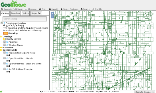
The GeoMoose core is written using JavaScript and HTML. It is entirely possible to run GeoMoose with nothing more than a basic web server (Nginx, Apache, IIS). GeoMoose 3.0 can perform complex queries like selecting, buffering and drill-down identify all without using a server-side scripting language. We exercise the functionality exposed by WMS, WFS, and other feature services to provide a dynamic experience for the user and easy administration.

Core features

  • Interactive Mapping

    • Searchable catalog of layers
    • Control layer opacity and stacking
    • Draw annotations the map
    • Clients upload temporary overlays (GeoJSON/KML)
    • PDF Printing
    • Desktop and Mobile ready
  • Data Sources

    • OGC WMS/WFS
    • GeoJSON
    • GML
    • KML
    • XYZ Tiles (e.g. Open Street Map)
    • ArcGIS REST
    • Bing Maps (requires API key)
  • Powerful Query Tool

    • Drill down identify tool
    • Query layers from polygon
    • Interactive table of query results linked to map
    • Download query results as CSV
    • Buffer selection/query results
    • Use query results as source for another query

Implemented Standards

  • Geographic JSON (GeoJSON)
  • Geography Markup Language (GML)
  • Keyhole Markup Language (KML)
  • Web Feature Service (WFS)
  • Web Map Service (WMS)
GeoMoose 3 Screenshot

GeoMoose News

View all press releases

Service Providers

Core contributors

View all service providers